Ucts are naviform cores, ridge blades, adzes, axes, hammer-stones, and arrowheads.
Below Stratum II. Evidence for the sporadic utilization of the site during the Late Neolitliic (Neolithic 3-4) and Chalcolitltic periods was recovered in fills and on occasional patches of surfaces encountered beneatli die stratum II buildings. An identifiable small collection of artifacts includes typical Late Neolithic flint tools, pottery sherds of the Jericho IX and Wadi Rabbah horizons, and a basalt bowl decorated with incised triangles and vessels similar in shape to Neolithic pottery types but fashioned of lime, apparently a late manifestation of the vaisselles blanches tradition. A very schematic minuscule ceramic figurine, with enlarged proboscis, conical head, and ears only, either anthropomorphic or zoomorphic, apparently belongs to this horizon.
Stratum II. Remains of a densely occupied village of more than a score of curvilinear houses, may indicate a break witii tire rectilinear tradition that dominated domestic architecmre from PPNB times to the end of tlie Chalcolithic period. These houses were found often directly on top of tite stratum IV structures. Their stone foundations, varying greatly in size, were either circular (e. g., 4.5 m in diameter), oval (5-8 m long), or sausage-shaped (i. e., two parallel walls (12-16 m long) ended in an apse at both ends. Occasionally, the curved ends were paved with flat stones; the larger structures had curvilinear internal walls. These buildings are part of a short-lived but strong curvilinear architectural tradition that can be traced from Byblos in the nortii to Ashkelon in the soutii in the Byblian Chalcolithic and local Early Bronze I period (fourth millennium bce). At Yiftahel, some slight evidence suggests as many as three phases within this period, but most of the haphazardly arranged buildings appear to have been contemporary.
This occupation’s early EB I date is indicated by numerous examples of Gray Burnished (“Esdraelon”) ware, as well as some typical vessels that continued Chalcolitliic ceramic traditions but with such distinctive EB I features as indented ledge handles. The lack of grain-wash or band-slip decoration bolsters tite argument for an early date wititin the EBI.
The flint-tool lot was primarily ad hoc, with Canaanean blades being extremely rare. The ground-stone assemblage included some typical finely worked EB I basalt bowls and a number of loaf-shaped basalt grinding stones. Two ax-heads and a delicate needle are tite only copper finds.
Faunal remains suggest that sheep, goat, cattle, and swine were herded. The economy appears to have been somewhat mixed, with tite addition of cereal production suggested by a number of flint blades bearing distinctive traces of sickle sheen.
Stratum I. A conglomeration of structures that were probably not all contemporary appears in stratum I. Two multichambered rectangular buildings with cobble pavements were devoid of finds and of uncertain date. Another enigmatic structure, a wide strip of fieldstones of varying widths, was found directly above several stratum II houses. Several poorly preserved walls and adjacent earthen surfaces were assignable, on the basis of typical pottery finds, to tiie Early Bronze IV and the Middle Bronze II-III horizons.
BIBLIOGRAPHY
Braun, Eliot. “Of Megarons and Ovals: New Aspects of I. ate Prehistory in Israel.” Bulletin of the Anglo-hrael Archaeological Society 6 (19851986): 17-26. Brief, preliminary report on the excavations at Yiftahel,
Braun, Eliot. “The Problem of the Apsidal House: New Aspects of Early Bronze I Domestic Architecture in Israel, Jordan, and Lebanon.” Palestine Exploration Quarterly 21 (1989): 1-43. Summary of all tire available evidence up to 1989, but now somewhat dated. Braun, Eliot. “Basalt Bowls of the EB I Horizon in the Soutliern Levant.” Paleotienl 16,1 (1990): 87-96. Typological study.
Garfinkel, Yosef. “Yiftahel: A Neolithic Village from dre Seventh Millennium B. C. in Lower Galilee, Israel.” Journal of Field Archaeology 14 (1987): 199-212. Preliminary report on the excavations of the small sounding in the early PPNB levels.
Garfinkel, Yosef, and Liora K. Horvvitz. “The Pre-Pottery Neolithic B Bone Industry from Yiftahel, Israel.” PaUorient 14.1 (1988): 73-86. Includes preliminary results of the faunal assemblage.
Ronen, Avraham, et al. “A Plastered Floor from tire Neolithic Village, Yiftahel (Israel).” PaUorient 17.2 (1991): 149-155. The most recent technical study of Yiftahel’s lime plasters.
Rosen, Steven A, “The Analysis of Early Bronze Age Chipped Stone Iirdustries: A Summary Statement.” In Vurbanisation de la Palestine a I’dge du Bronze ancient Bilan el perspectives des recherches actuelles; Acles dll Colloqiie d’Emmaus, 30-24 octohre igS6, edited by Pierre de Miroschedji, vol, i, pp. 199-222. British Archaeological Reports, International Series, no, 527.1. Oxford, 1989. Excellent summary of the subject.
Wright, G. Ernest, “The Problem of the Transition between the Chal-colitlric and Bronze Ages.” Eratz-Israel$ (1958): 37*-45*. Somewhat dated but still useful introduction to the Chalcolithic and EB I transition, with valuable observations on the ceramic evidence for tire northern region of the southern Levant,
Eliot Braun
YIN'AM, TEL (Ar., Tell en-Na‘am), an open-air site astride tire Darb el-Hawarneh, tire ancient road used as an international highway for trade and cultural difllision from the Late Bronze Age until tire early twentieth century CE to connect the Hauran in Syria witir Aldco in Palestine (32°43' N, 35°3' E; map reference 198 X 235). One of tiiirteen archaeological sites in a nortliwest-southeast-trending valley in tire eastern Lower Galilee, Tel Yin'am is adjacent to Wadi Fajjas, near an inland branch of tire Via Maris, at tire eastern edge of an alluvial fan of basaltic soils tliat slopes from tire Yavne’el scarp on the west side of tire Yavne’el Valley. The site was occupied from tile Yarmuldan Neolithic until the Late Roman period. Altliough it is frequently identified witir biblical Yavne’eljabneel (Jos. 19:33), it is not the only Iron Age site in tire vicinity. Beth-Gan, which yielded transitional LB/Iron and Iron I material, is anotlier candidate. [5ee Beth-Gan.] In the Jerusalem Talmud {Meg. 1:1, 70A) biblical
Yavne’el, a town at the southern border of the tribe of Naph-tali, is identified with Kliirbet Yamma, but no Iron Age material has been recovered from that nearby settlement. Early efforts to identify Tel Yin'am with Yeno'am in New Kingdom Egyptian sources are now generally disregarded. However, because the site yielded a significant LB II occupation and ended in a fiery destruction, its identification with Yeno'am, which some scholars believe to have been in the Bashan (Na’aman, 1977), may not be out of the question.
The site’s rich alluvial soils and ample water supply from springs and wadis fostered an agriculturally based economy, but its inhabitants also engaged in trade and ironworldng at the end of the Late Bronze Age. The site’s location accounts for its trade connections and the variety and quality of its material culture.
The earliest exploration of the site was conducted by tlte Palestine Exploration Fund during the survey in western Palestine in 1873. Aape Saarisalo subsequently surveyed the site and carried out a sondage (which the present excavation identified by loose fill and a metal can in square Kio in the 1920s). He believed Tel Yin'am to be the key archaeological site in tire valley and claimed that it had been occupied during tlie Bronze and Iron Ages and tlte Hellenistic, Roman, and Arab periods (Saarisalo, 1927). The site was later surveyed by Yohanan Aharoni and again by Ruth Amiran (Aharoni, 1957). The most recent survey, prior to systematic excavations, was conducted by Zvi Gal. His report (1992, p. 33) relied on the assessment of the site, as of 1981, by the University of Texas, which excavated there, under the direction of Harold Liebowitz, from 1976 to 1981 and 1983 to 1989.
In preparation for those excavations, Liebowitz conducted a sondage on tlte north side of the mound in 1975. Work was focused on the north and west sides of the mound (areas A and B). Area C, on the south side, which was badly eroded, was excavated for only one season. In 1978 a brief salvage dig was carried out 50 m west of the foot of tlte mound in area D, a terrace. The final seasons on excavation revised tlte site’s occupational history. It is now known to have had fewer gaps in occupation than originally assumed. Its broad repertoire of pottery and small finds (see below) have helped to define the eastern lower Galilee as a distinct region in the Late Bronze Age, heretofore considered to have been basically unoccupied in that period.
Neolitltic and Chalcolithic Periods. While the material evidence attests to tlte occupation of tlte site in tlte Neolithic and Chalcolithic periods, these levels were not reached in excavation because of the compaction of the soil below the EB I layers. The Neolithic pottery closely parallels assemblages from other Yarmultian sites (Stekelis, 1972), and the serrated flint blades recall sickle blades known from numerous Neolithic sites. The Chalcolithic period is attested primarily by large basalt hammers.
Bronze Age. The Early Bronze Age lA is best represented in area D(ioX losqm), excavated on tlte terrace settlement (see above). There, a circular platform identified as a bama was found in association witli partially preserved walls. The surface of die area was to cm thick and produced a rich, densely packed assemblage of EB lA pottery paralleled at Khirbet Kerak (and some Neolitltic pottery), a miniature basalt bowl, a rare ceramic bull protome, and a profusion of animal bones. A less significant EB layer was excavated on the west side of the mound.
The Middle Bronze Age is represented by the southwest conter of an MB fortress temple in a poorly preserved area immediately below the earliest phase of an LB II building in area B. The surface patch yielded an almost intact electrum figurine of a standing goddess that has parallels in silver from a temple at Nahariyah in Israel and at Syrian sites; and a flat, copper/bronze standing figurine with parallels at Byb-los. These figurines from Tel Yin'am were found in association with an MB II cooldng pot and tlie upper part of a large, unusual jar with plastic and incised decoration. The northern part of the sttucture had been bulldozed by a local farmer prior to excavation; its southeastern part remains unexcavated. Other MB II sherds were found in fills elsewhere in area B.
The tell was abandoned until the latter part of tlie Late Bronze Age. A ten-room central building (building i) that served as the residence of the local ruler existed throughout the LB occupation and yielded finds including cylinder seals, a stamp seal, a necklace witli a chalcedony lion pendant, and beads (including two gray-and-white barrelshaped beads), two Egyptian heart amulets, a bronze plow point, an “Egyptian Blue” shallow bowl, basalt bowls, and millstones. [See Seals.]
Additional thirteenth-century buildings abutted building i; all experienced two phases of occupation. On tlte cobbled floor of tlte storeroom of building 2 from tlte later phase, a dense concentration of sherds was found from which unusually large biconical jugs, store jars, and an unparalleled Mycenaean stirrup jar were restored, substantiating, along with the small fiitds (see above), the extent of foreign trade in the Late Bronze Age. The floor of building 7 was paved with meter-long flagstones. A 50-cm deep layer of ash, charred wood, fire-cracked rock, and burnt and disintegrated mud brick found on the floors of the major LB buildings was evidence of their violent end. In tlie final LB phase, room I of building i was turned into an industrial installation that apparently was a primitive iron smelter, heralding the coming of the Iron Age (see below).
Iron Age. The reuse in some places of LB walls in the Iron I settlements and floors laid directly above the LB destruction debris suggest that a relatively short period elapsed between destruction and resettlement, The Iron I buildings were sturdily built, and the pottery was of consistently high quality. Though much of the western slope of the mound is eroded, and a significant portion of tlie Iron I levels was destroyed, tlte preserved remains attest that the site was continuously occupied throughout the Iron I and into Iron IIA (the tenth century bce) .
The courtyard of one of two tenth-century (Iron IIA) domestic buildings in area B yielded an oil press, an olivecracking installation, stone weights, and olive pits, suggesting the existence of a home industry. [5ee Olives.] A long room north of the courtyard yielded forty-five loom weights. Unusual small finds include a rare bintetallic knife and a cone-shaped seal that features two rampant longhorns, each with a human figure seated on its back. Only two loci produced rich assemblages of Iron IIC ceramic remains in situ on the mound, although large quantities of sherds were found scattered tliroughout the area. A homogeneous assemblages of Iron IIC cooking pots, jugs, and store jars was restored from a courtyard and a partially excavated building in area B. Building activity in the Persian period had considerably disrupted remains in that level.
Persian-Roman Periods. Evidence of a Persian period occupation at the site was found in two phases in areas A and B. The ceramic assemblages reflect local and imported wares, including bowls, jugs, juglets, store jars, cooking pots, and a large pilgrim flask; among the imports were an East Greek painted jug and Attic sherds. The period’s most substantial remains were recovered in area B on the tell: a partially excavated building with walls one meter wide and a large stepped podium with a flagsone walkway leading to it. In area A a building witlt ovens and grain silos, whose dimensions suggest domestic use, was excavated. The site yielded no evidence of occupation in the Hellenistic period but was reoccupied in the Roman period. The domestic structures were comprised of two rooms and appear to have been small. The one exception is a building in area A, on the north. It was partially excavated along witli Roman-period buildings in area B. There, because the mound sloped sharply, the western continuation of tlte walls and floors of several rooms was eroded. Unique to area C are the limestone aslilars used in the building tltat housed a six-stepped, plaster-lined miqveh. {See Ritual Baths.] Though carbon-14 tests conducted on the plaster from the miqveh’s walls suggest a sixth-century date, tlte pottery is Late Roman. The absence of Byzantine and Arab pottery eitlter in Gal’s survey or in excavation leads to the conclusion that the site was abandoned at some time prior to the fourth century.
BIBLIOGRAPHY
.'Mtaroni, Yohanan. The Settlement of the Israelite Tribes in the Upper Galilee (in Hebrew). Jerusalem, 1957. See pages 79, 125, 129. Conder, Claude R., and H. H. Kitchener. The Survey of Western Palestine: Memoirs of the Topography, Orography, Hydrography, and Archaeology, vol. I, Galilee. London, 1881. See page 417.
Gal, Zvi. Lower Galilee during the Iron Age. Winona Lake, Ind., 1992.
Liebowitz, Harold. “Tel Yin'am.” Hadashot Arkheologiyot (1976): 29; 63-64 (1977): 29; 79 (UJ79): 20; 78 (1982): 17; 93 (1984): 24; 94 (1990): no.
Liebowitz, Harold. “Ivory.” Israel Exploration Journal 27 (1977): 5354; 28 (1978): 193-194; 29 (1979): 229-230; 32 (1982): 64-66.
Liebowitz, Harold, and Robert L. Folk. “Archaeological Geology of Tel Yin'am, Galilee, Israel.” Journal of Field Archaeology 7 (1980): 23-42.
Liebowitz, Harold. “Excavations at Tel Yin'am: The 1976 and 1977 Seasons, Preliminary Report.” Bulletin of the American Schools of Oriental Research, no. 243 (1981): 79-94.
Liebowitz, Harold, and Robert Folk. “The Dawn of Iron Smelting in Palestine; The Late Bronze Age Smelter at Tel Yin'am, Preliminary Report." Journal of Field Archaeology ii (19S4): 265-280.
Liebowitz, Harold. “Tel Yin'am.” Qadmoniot 19 (1984); 12-15.
Liebowitz, Harold. “Yin'am, Tel.” In The Anchor Bible Dictionary, vol. 3, pp. 584-587. New York, 1992.
Na’aman, Nadav. “Yenoam.” Tel Aviv 4 {igj'/): 168-177.
Saarisalo, Aape. 'The Boundaiy between Issachar and Naphtali: An Archaeological and Literaty Study of Israel’s Settlement in Canaan. Helsinki, 1927. See pages 44-45.
Harold A. Liebowitz
YODEFAT. S'ee Jotapata.
YOQNE'AM, site situated at the nortliern outlet of Wadi el-Malih into the Jezreel Valley, at the eastern foot of Mt. Carmel (map reference 1604 X 2289). The site covers an area of 10 acres. Rising steeply above the surrounding valley, Yoqne'am’s location commands the vital junction of tiie route tltrough tlte Malih Valley tliat connects the Via Maris of file coastal plain witli die route across tlie Jezreel Valley tliat leads to tlie Plain of Aklto and beyond, to Phoenicia. Its strategic position accounts for its long occupational history, from the Early Bronze Age to the Mamluk period. Egyptian, biblical, Byzantine, and medieval references to the site, including topographical data, and the resemblance of its Arabic name, Tell-Qeimun, to ancient Yoqne'am, made its identification certain. Yoqne'am enjoys exceptionally favorable environmental conditions: moderate climate, fertile soil, and an abundance of water.
Exploration. The site was first surveyed by the Palestine Exploration Fund in tlie late nineteenth cenmry. In the early 1970S it was resurveyed by the Israel Survey. Excavations began in 1977 as part of the Yoqne'am Regional Project, carried out on behalf of tlie Instimte of Archaeology of the I-Iebrew University of Jerusalem, under tlie direction of Am-non Ben-Tor, and continued for ten seasons until 1988.
History. The earliest reference to Yoqne'am is on an inscription at Karnak in Egypt tliat records a military campaign into Canaan by Thutmosis III (c. 1468 bce). Yoqne'am (tlie Egyptian rendering is ‘nqn‘am, probably referring to the springs at tlie foot of tlie site) is site number 113 on that list. The site is mentioned three times in the Book of Joshua: its king is listed as one of the thirty-one Idngs Joshua defeated (12:22); “the river that is before Jokneam” is tlie border of the territory of the tribe of Zebulon (19:11); and as a Levitical city within Zebulon’s territory (21:34). Kammuna, in Eusebius’s Onomasticon (116, 21), six miles from Legio, on the road to Ptolemais (Akko), is probably to be identified with Yoqne'am. The most frequent references to the site, under the name Caymont, or Mons Cain (both deriving from a tradition identifying it with the place where Cain was killed by Lamech) are to be found in Crusader documents. After die conquest of Baldwin I, it became first a royal castie and somewhat later the center of a small lordship. After dteir victory in the battle of Hattin (1187), the Muslims held the site for a short time, during which it appears in sources as al-Qaimun (Yaqut 4.218). During tire next century it changed hands several times. The site is last mentioned in a Frankish-Mamluk treaty dated 1268, in which al-Qaimun is listed among the possessions of the sultan Qalawun. The monumental structure covering the site’s entire acropolis has been identified with tire caravanserai built in the mid-eighteenth century ce by Dahir al-Omar, ruler of tire Galilee. Whether it is indeed, or whether the remains belong to the site’s Crusader fortress, will be decided by tire brief rescue excavation currently in progress by the Israel Antiquities Authority.
Excavation. Five areas (A-E) were opened at the site and twenty-three occupation levels identified.
Early Bronze-Middle Bronze I (strata XXVII-XXIV). No in situ remains were found of any periods because in the areas excavated, subsequent builders, by founding their structures on bedrock, removed all previous architectural remains. However, sherds from all the site’s occupational periods, including Gray-Burnished, Abydos, and Khirbet Kerak wares, as well as reserve-slipped Syrian sherds, were found, and stratum numbers were assigned for future reference.
Middle Bronze Age IIA-B (strata XXIIIA-C, XXII). Three interconnected rock-cut, bell-shaped burial caves constitute the earliest and only in situ remains at Yoqne'am. In one of them were two skeletons placed in arcosolia. The pottery associated with titese burials dates them to MB IIA. The entrance to one of the caves was sealed by the site’s earliest defense system: a solid mud-brick wall and a glacis. The two phases of these fortifications are dated within MB IIA. Another wall, not as wide as the former, and an associated tower, built on top of the fortifications, are dated to MB IIB. Litde is known about the settlement’s interior.
Transitional Middle Bronze IIC-Late Bronze I (stratum XXIA-B). The remains of dwellings built over the MB IIA-B defenses indicate an unfortified settlement. It is characterized by a large number of infant jar burials dated to the seventeenth-sixteenth centuries bce.
Late Bronze Age II (strata XXA—B, XIXA-B). Four phases of an unfortified LB II settlement were discerned. The last of these had been violently destroyed, as indicated by a level of burnt debris more than i m thick covering all tite remains. The date of that destruction should be placed somewhere in the late tiiirteentii-early twelfth centuries bce.
Iron Age I (strata XVIIIA-B, XVII). After an apparently short occupational gap, the site was resettled in the Iron Age. Three architectural phases could be clearly discerned. The main architectural feature of the last phase is a house containing installations for the production of olive oil. Large amounts of pottery, both local and Phoenician or Philistine related, characterize titis phase. The final destruction of the Iron I settlement may be related to the conquest of the Jez-reel Valley by King David.
Iron Age II-III (strata XVI-XI). After a brief transitional phase, Yoqne'am was once again fortified. In the mid-tentir century BCE tiie city was surrounded by a massive casemate wall. A shaft cut into bedrock, whose excavation was not completed, probably led to the spring at the foot of the tell. The casemate wall was replaced in the ninth century by a defensive system consisting of two parallel walls. A peripheral street ran along the inner wall, separating tite defenses from the city’s residential buildings. These defenses went out of use in the late eighth century bce, probably as a result of the Assyrian conquest of northern Israel.
Persian period (strata X-VIII). Three phases of an unwalled settlement from the Persian period were uneartited.
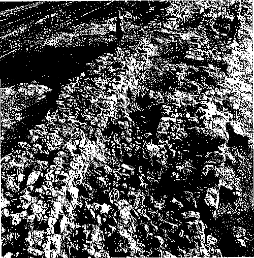
Yoqne'am. Iron Age double city walls. Ninth century bce. (Courtesy A. Ben-Tor)
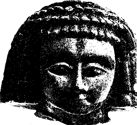
YOQNE'am. Iron Age faience head. Nintli-eighth century BCE. (Courtesy A. Ben-Tor)
A Strong Phoenician influence is clearly indicated in tlte architecture and tlte ceramic finds.
Hellenistic, Late Roman, and Byzantine periods (strata VII-V). A watchtower from the Hellenistic period and a mausoleum from the Late Roman period are all that remain of tlte later periods of occupation on the tell. The main settlement appears to have moved to tlte hill immediately to the south. This may have been the case also in tlte Byzantine period. I-Iowevetj remnants of a church located immediately under the Crusader church on the eastern slope of the acropolis indicate a Byzantine presence at Yoqne'am.
Early Arab period (stratum IVA~C). A well-planned settlement was found that apparently extended over the entire surface of tlte site during the Early Arab period. It is dated by finds whose origins are local as well as Syrian and Egyptian and belong to the eighth-mid-tenth centuries ce.
Crusader period (stratum IIIA-B). After an occupational gap of about two cenmries, Yoqne'am was rebuilt by tlte Crusaders. A residential quarter, a defensive wall, and a church are the main architectural features uncovered. There are clear indications of a massive fort having been constructed on tlte acropolis in tltis period, however.
Mamluk period (stratum II). Sporadic settlement occurred in the ruined Crusader city in the fourteenth century. It was confined mainly to the southern part of tlte site.
Ottoman period (stratum I). A few sherds and one tomb represent occupation during the Ottoman period (six-teentlt-twentieth centuries). Some building activity may have taken place in the ruined Crusader fort on the acropolis.
BIBLIOGRAPHY
Ben-Tor, Amnon. “An Egyptian Stone Vessel from Tel Yoqneam.” ‘AtiqotS (1970): 9*-io*.
Ben-Tor, Amnon, and Renatc Rosenthal. “The First Season of Excavation at Tel-Yoqne‘am, 1977.” Israel Exploration Journal 2S (1978): 57-82.
Ben-Tor, Amnon. “Yokneam et environs (projet d’etude regionale).” Revue Biblique&$ (1978): 96-100.
Ben-Tor, Amnon, and Renatc Rosenthal. “The Second Season of Excavation at Tel-Yoqne‘am, 1978.” Israel Exploration Journal 29 (1979): 65-83.
Ben-Tor, Amnon. “Yoqne‘am Regional Project Looks Beyond the Tell.” Biblical Archaeology Review 6.2 (1980): 30-44.
Ben-Tor, Amnon, and Renate Rosentltal. “The Third and Fourth Seasons of Excavation at Tel-Yoqne‘am, 1979 and 1981.” Israel Exploration Journal(1983): 30-54.
Hunt, Melvin L. “The Iron Age Pottery of the Yoqne'am Regional Project.” Ph. D. diss.. University of California, Berkeley, 1985. Poulin, Joan. “Du nouveau sur les Pheniciens.” Le Monde de la Bible 61 (1989): 58-61.
Amnon Ben-Tor


 World History

