The central Middle Ages was, in general, an era of economic vitality. Population grew, more land was brought under cultivation and both the number and size of towns increased. Commercial activity also expanded as individuals sought to sell surplus produce and to purchase commodities which were not available locally. This trade was focused on the markets and fairs of the Middle Ages. Many of these had developed during the early medieval period, in an ad hoc style now difficult to trace, at locations such as castles and monasteries. At specific times of the year large numbers of people congregated in these places for judicial, religious and other purposes and merchants realized that such groups were potential consumers. Here, too, in an age without the resources or requirement for permanent trading centres, merchants could meet and deal with other merchants. In the central Middle Ages landlords came to recognize that, through the imposition of tolls and other levies, profit could be made from the commercial activity at such gatherings. Licence from a landlord to hold a market or fair could also help to stimulate the economic fortunes of a new town. Consequently markets and fairs became the subject of seigneurial protection and regulation and they came to acquire a legal status. Markets were normally weekly events and mainly of local importance. Fairs, by contrast, were less frequent occasions and in many places were held only on an annual basis. Most were of between several days and several weeks duration and attracted merchants from further afield than the local market. Although some, such as Bozen's wine fair, Medina del Campo's wool fair and Skania's herring fair, specialized in particular commodities, most provided a venue for the exchange of a diverse range of local and more distant wares. While the overwhelming majority of fairs were of a mainly regional significance, a few, facilitated by good communications and developments in transport, rose to international prominence. In some areas cycles of sequential, neighbouring fairs emerged, providing merchants with virtually year-long trading opportunities. One of the earliest cycles had developed in Flanders by the twelfth century, based on the fairs of Ypres, Lille, Mesen, Torhout and Bruges, which were held between February and November. The most famous cycle, however, was located in Champagne. From the Lagny fair in January/ February merchants could progress to Bar-surAube, Provins and Troyes, returning to Provins and then the second Troyes fair in November/ December. The six Champagne fairs attracted merchants and merchandise from all over western Europe and were especially important as a point where Flemish cloth was exchanged for the commodities brought along
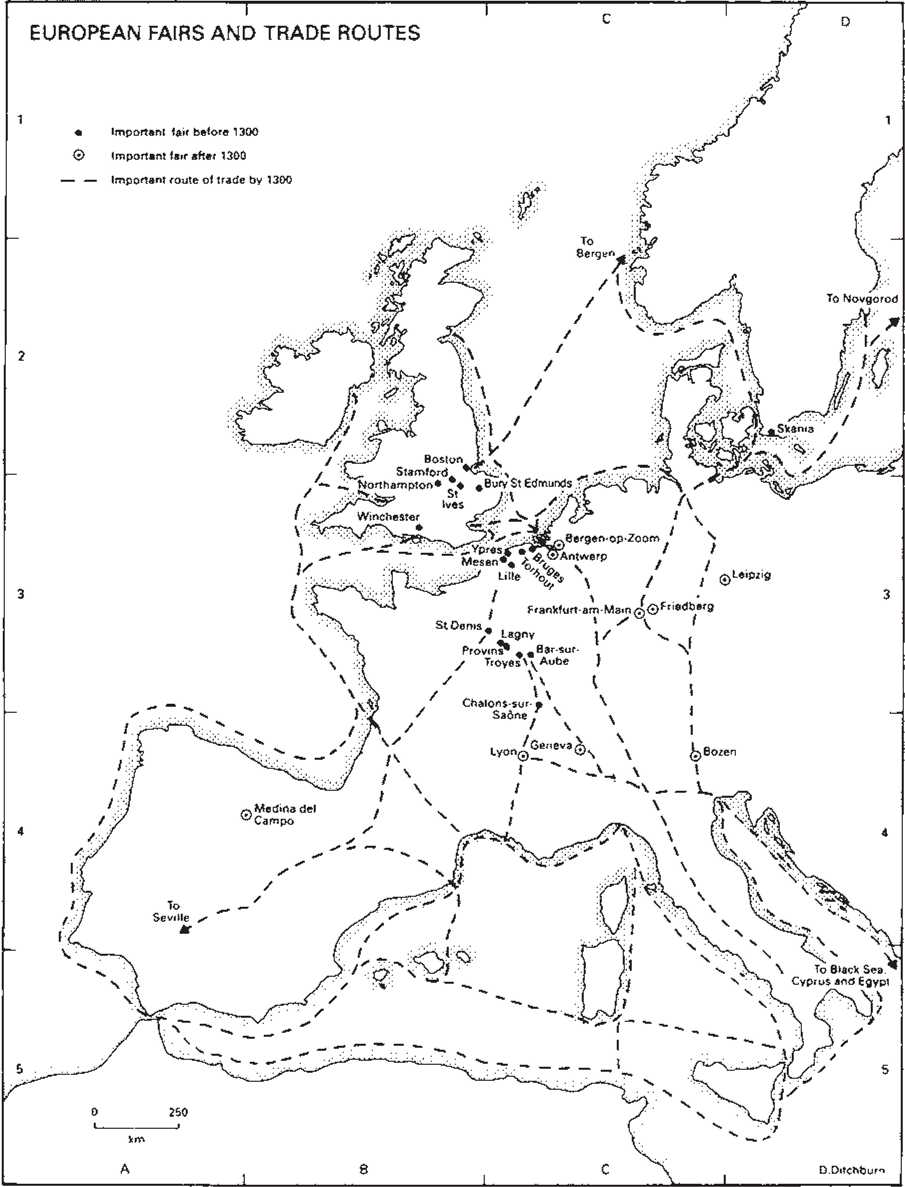
The Rhone-Saone route by Italian merchants. In the wake of this commercial activity the Champagne fairs acquired equal significance as a financial centre where money was changed, credit arranged and accounts settled. In the later Middle Ages other fairs, such as the Antwerp/Bergen-op-Zoom cycle and several in the developing regions of central and eastern Europe, rose to international stature. By contrast, however, the fairs of Flanders, Champagne and several others of international significance in the central Middle Ages were in decline by the early fourteenth century. In some instances local political instability contributed to this demise but economic factors were probably more important. The Champagne fairs were undermined by the development of the central Alpine passes and direct sea communications between Italy and northern Europe in the later thirteenth century. These new routes by-passed Champagne. The growing sophistication of business and financial techniques made direct personal contact between northern and southern European merchants in Champagne less necessary. More generally, commerce had become a year-long activity in the larger towns of western Europe. While markets remained central to commercial activity throughout the Middle Ages and after, it was no longer necessary to stimulate trading activity by means of a periodic fair.
D. Ditchburn
The Alpine Passes
The Alps were a major obstacle to the improvements. Nevertheless, winterjourneys were medieval traveller. By the later Middle Ages difficult or impossible and goods could only be there were a few guides, hospices and some road transported by pack animals. The lack of maps,
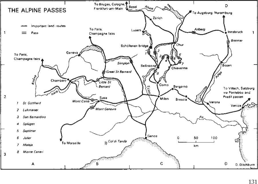
Dangers from avalanches and wild animals, and sudden weather changes exacerbated the usual problems of travel. From Carolingian times the Great St Bernard and Mont Cenis passes were used most frequently. They provided direct routes from Italy to the Champagne fairs of the twelfth and thirteenth centuries, while emperors campaigning in Italy favoured them since their approach roads passed through usually unaligned territories. From the 1230s, when a bridge was constructed at Schollerien, the western passes lost traffic to the Gotthard. It was easily reached from the north-west and the increasingly important south German fairs, such as Frankfurt-am-Main. Latterly English wool was also transported across the Gotthard, avoiding passage through hostile France. To the south, Monte Ceneri had a bad reputation for brigandage in the fifteenth century. Other central passes focused on Chur. The Septimer was the most popular of these, although it suffered from heavy snowfalls and a steep southern ascent. As military routes the central passes were less attractive as they converged on Como and Milan, traditionally hostile to emperors. After Austria's incorporation into the empire, armies increasingly used the Brenner. Its approach roads were direct and if necessary Verona could be easily by-passed. Low in height, it was also less susceptible to heavy snowfalls. With its proximity to Venice and the development of the central European economy in the later Middle Ages, the Brenner was also of growing commercial importance. It was one of the few passes across which wine could be transported and an important wine fair developed at Bozen. Further east, the Pontebba and, from the fourteenth century, the Predil, were used by merchants trading between the Veneto and Carinthia.
D. Ditchburn
The Larger Towns of Europe
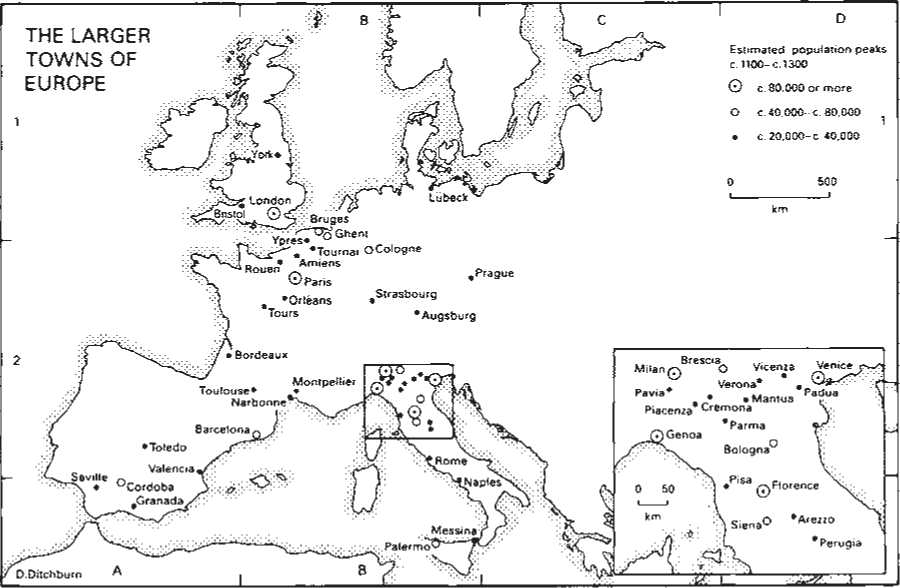
Towns and townspeople provide a contrast to the predominantly rural landscape and agrarian society of the Middle Ages. In many countries walls physically separated towns from the surrounding countryside and, to some extent, townspeople were subject to different laws from others. Economically, however, town and country were more closely integrated: the produce of the countryside was bought and sold in towns and rural areas provided raw materials for the urban craft industries. A significant number of townspeople, especially in the smaller towns, were even engaged in agrarian pursuits. Most medieval towns were, by modern standards, small. Even although the number and size of towns grew to accommodate part of the rising population of the central Middle Ages, their population was usually numbered in hundreds rather than thousands. Of the largest urban communities, a disproportionate number were located in northern Italy. In this region about forty towns probably had a population of over 10,000, including four of Europe's largest urban centres, the ports of Genoa and Venice and the manufacturing centres of Milan and Florence. Urban density was probably at least as great in both Flanders and Sicily where towns were generally smaller but more numerous. Calculating the exact population of medieval towns remains, however, difficult. Contemporary chroniclers routinely overestimated their size while little statistical data of the sort used by modern demographers survives for the medieval period. Instead historians have based their population estimates on a variety of other sources, including the physical size of towns, lists of townspeople compiled for taxation or military purposes and even figures of aggregate wine purchase. Such figures then require to be multiplied (selecting the appropriate multiplier is itself a controversial matter) to produce a population quotient. Different approaches can lead to gross discrepancies: Lucca's population has been estimated as 15,000 or 23,000; Paris's as 80,000 or 200,000; and London's traditionally as about 40,000 or more recently as at least 80,000. The accompanying map should, therefore, be regarded with caution.
D. Ditchburn
Families of Town Law
During the twelfth and thirteenth centuries many new towns were founded and old settlements raised to urban status. One common way of doing this was through the grant of the rights and privileges of an existing town. The result was the creation of 'families' of town law, groups of urban settlements whose legal arrangements were, at least initially, modelled on a 'mother town'. The mother town might be a major economic and political centre, like Lubeck, but some relatively unimportant places, like Breteuil in Normandy, also became the model for many towns spread over wide areas.
The degree of dependence between mother and daughter towns varied. Sometimes the new town was simply granted the customs of an existing town and there was no further connection. In other cases the affiliated town might turn to the mother town for a ruling when some point in the customs needed clarification.
An even closer bond existed in town families such as that of Lubeck, whose mother town heard judicial appeals from the courts of daughter towns.
The three families of town law shown here have been chosen to illustrate the variety of the phenomenon. The first, the family of towns with the law of Breteuil, was modelled on the small Norman town of Breteuil, which was enfranchised by its lord, William fitz Osbern, around 1060. After the Norman Conquest of England fitz Osbern became earl of Hereford and introduced the law of Breteuil into his Marcher lordship, whence it spread into surrounding areas of England and Wales. The Anglo-Normans who invaded Ireland in the decades after 1169 included many men, like the de Lacys, from this part of the country, and when they founded boroughs, like the de Lacy foundation of Drogheda, they too granted the laws of Breteuil.
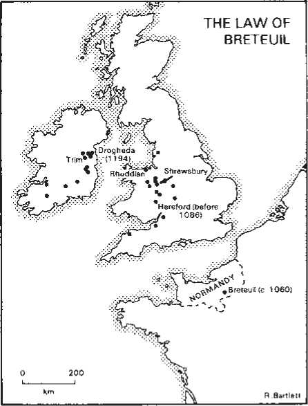
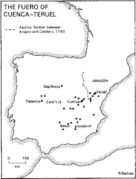
In this way, by a series of feudal conquests, the laws of a small Norman town came to be adopted by dozens of settlements in England, Wales and Ireland.
The law of Breteuil did not consist of a large or well-defined body of customs, indeed, its essence seems to have been the limitation of judicial fines to the low sum of 12 d. The law or fuero of Cuenca was a very much more elaborate affair. It contained almost a thousand clauses, regulating matters as varied as inheritance rights, criminal law, military obligations, Christian-Jewish relations, irrigation and pasturage, the public baths and the penalties for taking roses and lilies from another's vineyard. This comprehensive code was granted by Alfonso VIII of Castile soon after he had conquered the town from the Muslims in 1177. At about the same time a very similar code was granted to Teruel, across the border in Aragon, by Alfonso II of Aragon. Thus the family of Cuenca-Teruel law spread across political boundaries. As the reconquest pushed south, more towns were granted the fuero, some, such as Baeza and Iznatoraf in Andalusia, becoming the mother towns for yet further settlements.
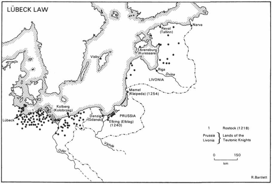
Lubeck law, originating in the twelfth century and codified in the thirteenth, was the basis for the most important of the three families of law shown here. It was a complex set of provisions governing commercial activity as well as criminal law and town government, and it provided the model for over a hundred towns founded along the Baltic shore in the thirteenth century. It served as the basic urban constitution for virtually all the towns of Mecklenburg and Pomerania. Because of its stress on urban independence some rulers found it suspect. The Teutonic Knights, for example, discouraged Lubeck law in their domains, preferring their own, less autonomous code, that of Kulm. Danzig and Memel, which originally had Lubeck law, were forced to abandon it under pressure from the Knights. Despite this resistance, however, Lubeck law was, in various forms, the dominant code of the Baltic, from the mother city itself to the frontiers of Russia.
R. Bartlett
The Contado of Lucca in the Twelfth Century
The commune of Lucca is first recorded with consuls in 1119, though it may have been autonomous since the 1080s. Like other Italian cities, it aspired to control the whole of its diocese; like them, it had to fight rural lords and rival cities in order to do so.
The core of the diocese was the rich plain around the city, the Sei Miglia or 6-mile territory, fully ceded to city jurisdiction by Henry IV in 1081; in this area, rival powers were weak, except along the frontier with Pisa, and all were destroyed relatively early (though Ripafratta, taken in 1105, ended up under Pisan control). The major problem the city faced was access to the sea, normally through the territory of its enemy. The Lucchesi and Pisans fought many wars over the issue, particularly when the Lucchesi tried to establish a port in their own diocese on the river Motrone, rather than go through Pisa. These wars reached their height in the 1170s, but they are a feature of the whole period. Elsewhere, Lucchese control was helped by the network of episcopal castles, for the bishop was generally a reliable associate of the commune, and by an early tendency for rural lords to live in the city. The military expansion of Lucca was largely along the major road routes east and south-east, and up the Serchio valley into the mountains. East and north, the Lucchesi found domination relatively easy, and they were only held back by the occasional hostile intervention of German emperors.
However, the Arno and Era valleys—in a geographical sense Pisa's hinterland—were absorbed into the latter's contado in the end, despite the episcopal castles in the area; the
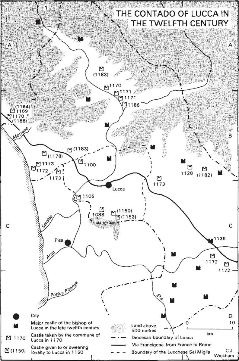
Lucchesi made no effective impact here. Hegemony over the rural lordships of the diocese was otherwise pretty complete well before the end of the century; only a rival city prevented it from being fully realized in the south, not any rural aristocrat.
C. Wickham


 World History
